|
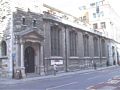
Location of St Katherine Cree
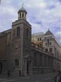
Other links to St Katherine Cree
Restaurants in the area
Chamberlains (distance = 338 m bearing 235°)
, Lanes Restaurant and Bar (distance = 358 m bearing 35°)
Local Pubs
Aldgate Wine Bar (distance = 173 m bearing 216°)
, All Bar One (distance = 409 m bearing 121°)
, Balls Brothers (distance = 481 m bearing 222°)
, Bangers Too (distance = 466 m bearing 222°)
, CJs (distance = 452 m bearing 230°)
, Counting Hoouse (distance = 500 m bearing 237°)
, East India Arms (distance = 148 m bearing 212°)
, Elephant and something (distance = 376 m bearing 228°)
, English Club (distance = 279 m bearing 125°)
, Florentines (distance = 482 m bearing 225°)
, Hoop and Graps (distance = 124 m bearing 213°)
, Hung, Drawn and Quartered (distance = 419 m bearing 219°)
, Jamaica Wine House (distance = 457 m bearing 237°)
, Simpsons (distance = 480 m bearing 237°)
, The Market Trader (distance = 421 m bearing 38°)
, The Pump House (distance = 337 m bearing 225°)
, The Ship (distance = 356 m bearing 226°)
, The Weatherspoon (distance = 433 m bearing 122°)
, Three Tons (distance = 160 m bearing 142°)
, Wine Lodge (distance = 394 m bearing 228°)
Shops in the area
Leadenhall (distance = 332 m bearing 236°)
Nearby sights
 122 Leadenhall Street (distance = 351 m bearing 237°)
, 20 Fenchurch Street (distance = 411 m bearing 228°)
, Bishopsgate Church Yard (distance = 467 m bearing 311°)
, George Yard - Barclays Bank (distance = 496 m bearing 236°)
, Swiss Re Tower (Gherkin) (distance = 176 m bearing 315°)
, Tower 42 (distance = 400 m bearing 322°)
, Trinity House (distance = 360 m bearing 123°)
, Trinity Square 10 (distance = 357 m bearing 121°)
, Old Turkish Baths (distance = 443 m bearing 310°)
, All Hallows by the Tower (distance = 447 m bearing 121°)
, Spanish and Portuguese Synagogue (distance = 98 m bearing 306°)
, St Andrew Undershaft (distance = 141 m bearing 327°)
, St Botolph Bishopsgate (distance = 418 m bearing 308°)
, St Botolph without Aldgate (distance = 191 m bearing 53°)
, St Dunstan in the East (distance = 486 m bearing 217°)
, St Ethelburga the Virgin (distance = 313 m bearing 315°)
, St Helen's (distance = 246 m bearing 318°)
, St Margaret Pattens (distance = 408 m bearing 223°)
, St Michael Cornhill (distance = 460 m bearing 237°)
, St Olave (distance = 325 m bearing 212°)
, St Peter upon Cornhill (distance = 427 m bearing 237°)
, Lloyds (distance = 270 m bearing 236°)
, Lloyds Register (distance = 146 m bearing 211°)
, Osborne House - Nation Association of Flowe Arrangers (distance = 371 m bearing 301°)
, London Underwriter Centre - Minster Court (distance = 390 m bearing 215°)
, Leadenhall Market (distance = 345 m bearing 236°)
, Merchant Navy and fishing fleets Memorial (distance = 433 m bearing 122°)
, Pepys, Samual (distance = 373 m bearing 31°)
, Poppies in the Moat (distance = 491 m bearing 123°)
, Tower Hill Scaffold (distance = 423 m bearing 122°)
, Devonshire Square (distance = 351 m bearing 302°)
, Mitre Square (distance = 59 m bearing 33°)
, St Helen's Place (distance = 297 m bearing 317°)
, St Michaels Alley (distance = 467 m bearing 237°)
, Widegate Street - Spitalfields (distance = 498 m bearing 32°) 122 Leadenhall Street (distance = 351 m bearing 237°)
, 20 Fenchurch Street (distance = 411 m bearing 228°)
, Bishopsgate Church Yard (distance = 467 m bearing 311°)
, George Yard - Barclays Bank (distance = 496 m bearing 236°)
, Swiss Re Tower (Gherkin) (distance = 176 m bearing 315°)
, Tower 42 (distance = 400 m bearing 322°)
, Trinity House (distance = 360 m bearing 123°)
, Trinity Square 10 (distance = 357 m bearing 121°)
, Old Turkish Baths (distance = 443 m bearing 310°)
, All Hallows by the Tower (distance = 447 m bearing 121°)
, Spanish and Portuguese Synagogue (distance = 98 m bearing 306°)
, St Andrew Undershaft (distance = 141 m bearing 327°)
, St Botolph Bishopsgate (distance = 418 m bearing 308°)
, St Botolph without Aldgate (distance = 191 m bearing 53°)
, St Dunstan in the East (distance = 486 m bearing 217°)
, St Ethelburga the Virgin (distance = 313 m bearing 315°)
, St Helen's (distance = 246 m bearing 318°)
, St Margaret Pattens (distance = 408 m bearing 223°)
, St Michael Cornhill (distance = 460 m bearing 237°)
, St Olave (distance = 325 m bearing 212°)
, St Peter upon Cornhill (distance = 427 m bearing 237°)
, Lloyds (distance = 270 m bearing 236°)
, Lloyds Register (distance = 146 m bearing 211°)
, Osborne House - Nation Association of Flowe Arrangers (distance = 371 m bearing 301°)
, London Underwriter Centre - Minster Court (distance = 390 m bearing 215°)
, Leadenhall Market (distance = 345 m bearing 236°)
, Merchant Navy and fishing fleets Memorial (distance = 433 m bearing 122°)
, Pepys, Samual (distance = 373 m bearing 31°)
, Poppies in the Moat (distance = 491 m bearing 123°)
, Tower Hill Scaffold (distance = 423 m bearing 122°)
, Devonshire Square (distance = 351 m bearing 302°)
, Mitre Square (distance = 59 m bearing 33°)
, St Helen's Place (distance = 297 m bearing 317°)
, St Michaels Alley (distance = 467 m bearing 237°)
, Widegate Street - Spitalfields (distance = 498 m bearing 32°)
Nearby Neighbours (Plaques)
CLAYTON, Reverend P.T.B. Tubby (1885-1972), (distance = 364 m bearing 121°)
, MALLON, Dr Jimmy, CH (1874-1961), (distance = 246 m bearing 33°)
, ROSENBERG, Isaac (1890-1918), (distance = 373 m bearing 54°)
, STRYPE STREET. (distance = 401 m bearing 35°)
Notorious sights in the area
Baltic Exchange - Bomb (distance = 170 m bearing 316°)
, Bishopsgate - Bomb (distance = 360 m bearing 309°)
, Execution Site - Tower Hill (distance = 433 m bearing 122°)
, Jack the Ripper - Catherine Eddowes (distance = 60 m bearing 49°)
, Mr Lloyds coffee house (distance = 425 m bearing 213°)
, Tower Hill - Disaster (distance = 433 m bearing 122°)
, Tower Street Explosion (distance = 425 m bearing 213°)
, Walsingham, Sir Francis (1532-1590) - Spys (distance = 348 m bearing 211°)
General Links Local Map
Map of what is in the area - using Google map
|